New Orleans Bienville Trail
Click Here for the Information Flyer
Length: 6.5 miles
Time to complete the trail: 2-3 Hours.
Description: Historic trail between the bayou and the Mississippi River discovered by Bienville in 1699. A patch is available for this trail.
Activities: Various monuments, museums, and Cathedrals can be visited
Start Point: Scout Island, City Park
End Point: Canal Street
History of the Bienville Trail
Jean Baptiste Le Moyne, Sieur de Bienville, discovered the bayou and trail in 1699. He named the bayou St. John for his patron saint. Bienville joined the French navy at the age of 12. When he was 14, he received his first battle wounds. He was 17 when he came to the Gulf Coast with Iberville, his older brother, to establish French posts to guard the lower river valley of Louisiana. As a Canadian scout and sailor, young Bienville was certainly a “boy” scout.
Long before the French came in 1699, Native Americans used this trail from the bayou to the river. It was called a portage because they ported, or carried, their canoes from the waters of the bayou to the river. In 1718, Bienville founded the city of New Orleans at the river end of the trail or portage. A person was able to walk about a mile from the river to Bayou St. John. He could then go by boat to Lake Pontchartrain which connected to the Gulf of Mexico by the way of Lake Borne. This was easier than going down the river, which was very difficult country, often flooded and filled with alligators, serpents, and other venomous beasts.
Trail Waypoints
- Leave Scout Island by turning left on to Harrison Avenue; follow Harrison Avenue to Marconi Drive; turn left. Continue on Marconi to Roosevelt Mall. Walk through Roosevelt Mall to the New Orleans Museum of Art.
- “Dueling Oaks” Approximately 200 yards to the left (when facing the Museum). Once this was a remote spot here the Creoles settled arguments with sword and/or pistol duels. The Creoles were the Spanish and French aristocracy of old New Orleans.
- Return to the Museum and proceed to the entrance of City Park. Cross the bridge and turn right on to Moss Street, continuing on Moss Street until you reach 1300 Moss Street. After crossing the bridge, look ahead and you will see many Spanish and West Indian-type plantation homes. In early Spanish days (from 1763-1803) this neighborhood was a summer resort and an important part of the port. The house at 1300 Moss Street is known as the “Spanish Custom House”. Read the plaque on the gate.
- Turn left at the Spanish Custom House and you are on Grand Route St. John – beginning of the overland portage from the bayou to the river. Note the historical marker near the bayou.
- Continuing along Grand Route St. John, you cross Esplanade Avenue for the first time. This was the fashionable street of the Creoles. Grand Route St. John ends at Gentilly road, where you turn right for two blocks, intersecting back with Esplanade Avenue.
- Take Esplanade Avenue to Rampart.
- Crossing Rampart, you are now in the Vieux Carre. They say the best way to see this world-famous neighborhood is to “get lost”, but Scouts should never get lost, so continue along Gov. Nicholls Street by the Old Spanish Stables at 724 to Royal Street. At this corner – 1140 Royal Street – is the famous Haunted House. Details of how it came to be haunted are vividly presented by Musee Conti, the city’s famous wax museum at 917 Conti Street, which you will visit later.
- Everything you see in the Vieux Carre is interesting. Continue along Gov. Nicholls to Chartres Street and turn right. Immediately across the street you will see the Ursulines Convent. This building is probably the oldest in the Mississippi Valley. It was completed in 1734 for the Ursuline nuns. After many years use as a convent, the building became the home of the Archbishop of New Orleans. It is a National Historic Site.
- Across the street from the convent is the Beauregard House, home of P.G.T. Beauregard House who was a general in the Civil War and later an engineer in New Orleans.
- Continuing down Chartres past many old and quaint places you come to Jackson Square – the Place d’Armes (or drill ground) of colonial New Orleans. Flanking the historic St. Louis Cathedral are the equally ancient Cabildo and Presbytere. The two long red buildings flanking Jackson Square are the Pontalba Buildings built in 1848-50 by Madame Pontalba. Each building contains sixteen apartments three stories high.
- Visit St. Louis Cathedral. An attendant is usually available to give you a short, guided tour. The Cathedral dates from 1794 but it is the third church on the site. A hurricane destroyed the first in 1723 and a fire burned the second in 1785. The Cathedral was named for Saint Louis, who was King of France in the 13th Century.
- Visit the State Museum at the Presbytere next door to the Cathedral. Admission for uniformed Scout groups has been free – call prior to hiking for current fee information.
- Take either Pirates Alley or Pere Antoine’s Alley on either side of the Cathedral to Royal Street. The small, enclosed park is St. Anthony’s Garden which used to be a famed dueling ground in the city’s early days. Cross Royal Street and follow Orleans Street down to Dauphine and turn left. Along the way you will see ceramic markers that mistakenly label this to be Bayou Road. In Spanish times this street was the rear of the city and travelers coming in the trail turned and followed the path of this street. You follow it to Conti Street. On the corner at 401 Dauphine is one of several houses reputed to have been occupied by John James Audubon.
- At Conti Street, turn right and proceed to Musee Conti at 917 Conti Street. Please call ahead for Scout group pricing if you wish to tour the museum.
- Return along Conti toward the river to Decatur, which used to be called Levee Street and to the triangle intersection where N. Peters starts – it used to be called New Levee Street. This is because the river kept changing its course and building up more land. Turn right on Decatur, continue on past the Customs House to Canal Street and turn left.
- You can now see the International Trade Mart, 33 stories tall, on the riverbank. Had it been built there when New Orleans was founded in 1718, the Trade Mart would have been in the middle of the river. The river at the foot of Canal Street is 100 feet deep. Over at the foot of Gov. Nicholls Street it is 200 feet deep.
The Bienville Trail Committee hopes you will “pass a good time” during your hike on the trail.
New Orleans Carrollton Historical Trail
Click Here for the Information Flyer
Length: 5.2 miles
Time to complete: 2-3 hours
Description: The trail follows the original path of the New Orleans and Carrollton Railroad. There is a patch for this trail.
Activities: This trail includes stops at Lee Circle and Lafayette Square
Trail History
The route of the New Orleans and Carrollton Railroad is covered when you follow the Carrollton Historical Trail and follow the original path. This rail line is one of the oldest street railways in continuous operation in the world. Today it is called the St. Charles Streetcar Line and still provides daily transportation for thousands of daily commuters and tourists along this recently remodeled roadbed.
The city developed uptown after 1835, along the route of this railway. Originally 9.2 miles long, the route extended from around Canal Street to what is now Carrollton and St. Charles Avenues. The railroad initially served the town of Carrollton, but later extended to Bouligny (Napoleon Avenue) and eventually the rest of uptown New Orleans.
The trail you will follow will pass through the lands of 13 plantations. Major points of interest include historic buildings and many examples of 19th Century architectural styles that are characteristic of New Orleans. Optional side tours of the Garden District, Coliseum Square, Audubon Park, and the French Quarter can be enjoyed.
The trail is indeed historic in that the street car line as well as the Garden District, Coliseum Square and the French Quarter have all been designated and listed in the National Register of Historic Places. The route gives an idea of what New Orleans looked like during the 19th Century.
It is recommended to begin the hike at Carrollton due to better parking options. However, the hike can be done from Canal to Carrollton, using the waypoints in reverse.
Waypoints
- Carrollton Courthouse (also formerly the site of Ben Franklin School) 719 S. Carrollton Avenue. Construction began for this building in 1854 and was completed in late 1855. Once the courthouse for Jefferson Parish prior to Carrollton’s annexation by New Orleans in 1874, this building has served as a courthouse as well as the site for several public schools. It is slated to become a senior living facility. During its use as a courthouse in 1858, the case Joseph Tom v. The Slave Ernest was heard, and the district judge decided that “Slaves are persons, not things, and cannot therefore be seized provisionally.”
- Camelback houses (1806) 7628-34 St. Charles Avenue.
- Dominican College (1882)
- Doll House (7209 St. Charles Avenue)
- Audubon Place (on your left)
- Audubon Park (on your right)
- Tulane University
- Loyola University
- Wedding Cake House (1894) 5809 St. Charles Avenue
- Tara Reproduction (Gone with the Wind) 5705 St. Charles Avenue.
- Sacred Heart Academy (1897) 4521 St. Charles Avenue
- Unity Temple (1960) 3722 St. Charles Avenue
- Christ Church Cathedral 2919 St. Charles Avenue
- The Garden District (runs from Louisiana Avenue to Jackson Avenue)
- Lee Circle and the Confederate Museum; the National World War II Museum is also close by.
- Julia Row at 600 Julia Street
- Gallier Hall (former City Hall) 525 St. Charles Avenue
- Lafayette Square
Now you can visit the French Quarter or return to South Carrollton via the streetcar. Streetcar fares are $1.00 each and you must have either a token or correct change.
Tuxachanie Trail
Click Here for the Information Flyer
Length: 11.9 miles
Time to complete the trail: 4-6 Hours.
Description: The trail lies from East side of Highway 49 North to Airey Lake to the old-World War II POW Camp.
Activities: The trail features hiking, nature, camping, and history
Start Point: East side of Hwy 49 N about 20 minutes North of Gulfport, Ms.
End Point: an abandoned site of a WWII German Prisoner of War Camp and Navy Rifle Range.
History of the TuxachanieTrail
The trail features hiking, nature, camping, and history and is directed toward such groups as BSA Scouts, Girl Scouts, Explorers, Ventures, and other youth groups. Groups taking the trail should have one adult for every eight to ten youth for safety measures and all scouts should conduct themselves as Scouts.
The trailhead is on the East side of Hwy 49 N about 20 minutes North of Gulfport, Ms. and is approximately 11 miles long and well maintained. It is well marked with white rectangle blazes and mile markers. It is a very interesting, educational, and enjoyable hike and open all year round. The trail provides an educational expedition for Scouts and Scout leaders and to create interest in our national forest and the historical significance of the Prisoner of War Camp.
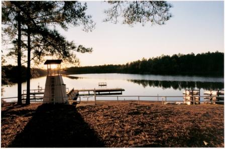
Camping is permitted at Lake Airey and at the POW camp. Camping facilities are available for units wishing to camp overnight. Units who wis to camp should bring their own tents, camping equipment and water containers. Water and sanitary facilities are available only at Airey Lake, no shower facilities. There are picnic tables and bbq/fire pits in the campgrounds. Primitive camping is available at the POW camp. Both camps are accessible by road.
At the end of the trail lies the prisoner of war camp. This is an abandoned site of a WWII German Prisoner of War Camp and Navy Rifle Range. The building foundations are still visible, the permanent overnight campsite offers an open, grassy camping area in the shade of Longleaf pines. The camp is accessible from the trail entrance on Highway 67 and County Road 402. Here, the hiker may relax and recall forest resources and activities they have seen along the Tuxachainie hiking trail.
Trail Waypoints
- The trailhead is on the East side of Hwy 49 N about 20 minutes North of Gulfport, Ms.
- 1.4-mile marker
- 3.3-mile marker
- 5.3-mile marker you arrive at Airy Lake.
- 7.9-mile marker
- The trail ends at a WWII German Prisoner of War Camp and Navy Rifle Range.
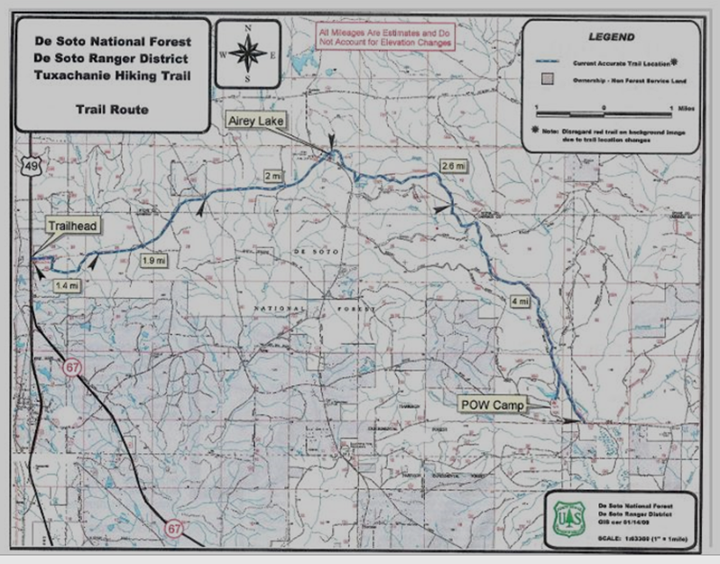
Regarding the map above and what appear to be distance markers. The first marker on the map reads “1.4 mi.” and the second reads “1.9 mi.” This is meant to indicate that the distance between the outlier arrows is as noted. It does not mean that it is 1.9 miles to the third arrow. The combined distance therefore is 1.4+1.9 or 3.3 miles.
If read correctly, from the trailhead to Airey Lake would be 5.3 miles (not just over 2 miles).